| Name: | Goose Creek Falls |
| Type: | Out and Back |
| Trailhead: | Goose Creek Falls Trailhead |
| Map: | AllTrails |
| Round Trip Length: | 3 miles |
| Time: | 2 hours |
| Nearest City: | McCall, ID |
| Best Time of Year: | July-October |
| Elevation Gain: | 820 ft |
| Highest Point: | 5,739 ft |
Picking a trail in an area overflowing with hiking opportunities can be challenging. Do you prioritize panoramic views, riverside walks, or alpine mountain lakes? For a lot of us, our fitness level will make the decision. However, one outdoor attraction always gets shoved to the top of our list. Goose Creek Falls in Idaho was no exception to this rule.
Powerful, Majestic, Awe-Inspiring, other fancy adjectives… Of course, I am talking about waterfalls. I can’t get enough of them. You could spill a glass of water over the edge of a table, and I’d probably take a picture of it. There is just something so calming about the look and sound of cascading water.
With our bias towards rushing water, the Goose Creek Falls trail was a logical choice on our visit to McCall, Idaho.
The well-maintained trail is short but steep at 3 miles roundtrip with 820 feet of elevation gain. On this highly rated, out and back journey, you’ll see two waterfalls and spend some time among towering ponderosa pines.


Trailhead
The trailhead for Goose Creek Falls in Idaho is very easy to find. Heading North from Boise, you’ll make your way past the city of McCall and head towards Brundage Mountain Ski Resort. After turning right onto Brundage mountain road, you’ll drive less than a quarter-mile before you see the sign for Goose Creek Falls. Obey the arrow and turn left. You’ll wind down a dirt road to a huge gravel parking lot.
Goose Creek Falls Trail
The trail starts at the sharp turn you took coming down to the parking lot. Backtrack up the road past the bathroom and the useless trail information sign, and you’ll see the start of the trail on your left.
The trail briefly starts at an incline but then dips down for the remainder of the out portion of this route. You know what that means, coming back is all uphill. Remember to pace yourself. But try not to think about the slog of high uphill stepping that awaits you and be in the moment. Focus on being surrounded by big beautiful trees. Occasionally the trees will part, and you will have a chance to look up and down the adjacent valley.
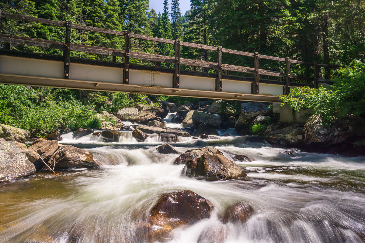
At around 1.25 miles, you’ll come to a bridge and the first waterfall. I call it a waterfall, but realistically it’s probably more of a rapid. Either way, spend some time admiring it. The running water’s sound echoes off the pines and drowns out all other sounds.

A few people mistake this for Goose Creek Falls and turn around. The actual falls are another quarter mile past the bridge. Continue over the river and through the woods, to Goose Creek Falls we go. Right when you cross the bridge, you’ll see a trail junction sign which will keep you on the right path.
Right before you get to the falls, the trail will start going up and kind of peters out. Follow the hump over some rocks, and you’ll soon see the top of the falls. From this point on, the official trail ends, but there is a lot of exploring you can do in the area. If you brought lunch, you could find some great picnic spots as you move down the mountain following the river’s path.

When you’re done exploring, head back the way you came. I can tell you from experience the way back is a grind. If you’ve read some of our past trail guides, you know I loathe trails the start downhill and finish uphill. But you really don’t have a choice here, its time to embrace the suck.
After the hike, do your muscles a favor and head over to Ponderosa State Park and hop in the cold lake water. Your calves will thank you.


One response
[…] Click here for a map and trail guide. […]