
Name: Perrine Coulee Falls
Type: Out and Back
Trailhead: Multiple Starting Points
Map: Google Maps
Length: Varies
Time: 10 minutes to 2 hours
Nearest Major City: Twin Falls
Best time of year: Year Round
Elevation Gain: 54 ft
Highest Point: 3455 ft
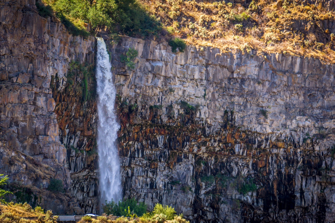
French Fries are amazing but they are not a meal on their own. That is how I feel about Perrine Coulee Falls. It’s not something you should drive all the way to Twin Falls, Idaho for but if you are in the area, it makes a great side stop. The waterfall is around 200 feet tall and flows all year round. While the waterfall is gorgeous, the best part of this trail is the ability to walk right behind the waterfall.
Where to start?
There is no official trailhead for this hike, but there are several ways to get to it.
The Short Way
The shortest path starts at the first hairpin turn as you come down Canyon Springs road. There is virtually no parking here. Most people pull off to the shoulder to park but be aware there is no visibility coming around that turn. The safest thing to do is park up at the top of Canyon Springs road and walk down. Or you can drive past the unofficial trailhead and park down the road near the Cenntenial Waterfront Park Sign and backtrack up to falls.
To get to the falls from the short side, you will have to get a little wet. Past the cement barrier, there are some openings in the bushes. Duck your head and follow the rocky stream to get to the trail. The mist from Perrine Coulee Falls will make the trail damp so be ready to get your shoes a little muddy as well.
The Long Way
If you want a little more hiking there is a trail that comes in from the other side of the waterfall but it is difficult to find and Google Maps isn’t accurate. If you look it up on the Google Maps or Earth you can see a clear trail. In reality, much of that is now overgrown making it very difficult to find the beginning of the trail. I can’t tell you where the trail officially starts. My best advice is once you see the trail carefully bushwhack to it. But quite honestly it’s just easier to go the short way.

Behind the Falls
It’s pretty rare that you get a chance to be so close to a big waterfall. It’s even rarer to have the chance to go behind it. Perrine Coulee Falls jettisons over the West Snake River Canyon Rim. This creates a gap between the canyon wall and the waterfall. The result allows you to easily pass behind the water.
Explore Some More
While Perrine Coulee Falls is truly a unique experience, it isn’t the only thing in the area worth exploring. Continue down the Canyon Springs Road and take a walk around Centennial Waterfront Park. There are some great views of the Snake Canyon and Snake River.
The large bridge spanning the canyon is Perrine Memorial Bridge. Stay long enough and you can see base jumpers leap from the bridge, releasing their colorful parachutes and gracefully spiral down to the river’s edge. Not something I would ever do, but fun to watch nonetheless.

If you’re driving the stretch between Twin Falls and Boise, and you haven’t gotten your fill of waterfalls yet, stop by Malad Gorge State Park for another great waterfall experience.


One response
[…] If you do feel like hiking the trail, you can find more information here. […]