
Trail Details
- Type: Loop
- Trailhead: 44.869346, -115.974857
- Length: 7 miles
- Time: 5 hours
- Nearest City: McCall, ID
- Best time of year: June
- Map: http://www.trimbleoutdoors.com/
High altitude lakes, also known as alpine lakes, are some of the most peaceful backdrops you can ever encounter. An untouched body of water surrounded by mountains and peaks hidden away in a sea of green forest. Typically you have to put in some serious legwork to get to an alpine lake but it is worth the effort.
The Louie Lake/ Boulder Lake loop is great for those who want rewarding lake views without having to gain too much elevation. The 7-mile loop will take you up to the serene Louie Lake, over the ridge of Twin Peaks and down to Boulder Lake.
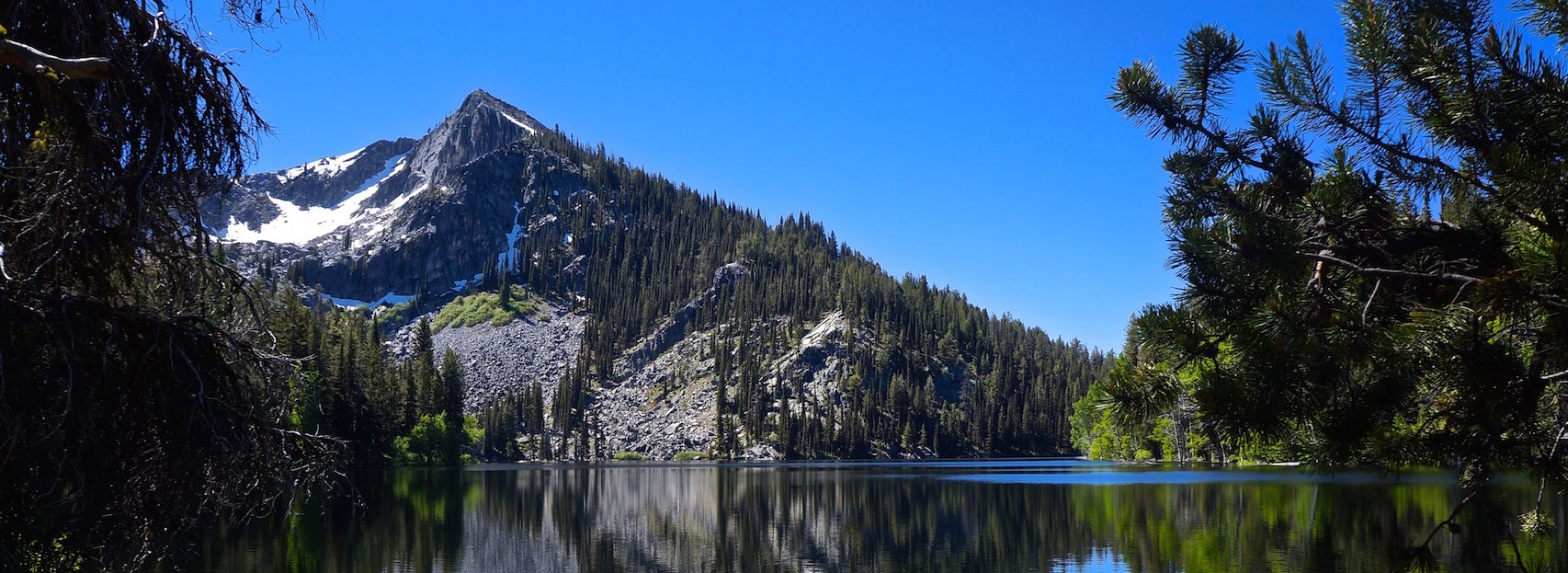
Louie Lake

Louie Lake
The trailhead for Louie Lake is buried pretty deep in the woods. You leave the highway to travel on some unmarked dirt roads until you reach an unnamed campground. Once you leave the pavement don’t over think the directions. The roads are unmarked but just keep going straight. Don’t veer off and eventually you will reach the wooded camp where a trailhead sign for Louie Lake awaits.
At the trailhead sign, you will immediately have to cross over Boulder Creek. There isn’t an actual bridge but there are several logs lumped together for your convenience. After the crossing, you will head uphill to a jeep trail. Head left and continue on until you find a large rock that has some faint graffiti on it directing you to the lake. You will then travel roughly 1.5 miles until you reach the lake.
The anticipation is built as you crest over a small hill where you are greeted with a postcard view. The lake has an intense calming effect as Jughandle mountain stands in front of you and reflects off the glassy water. Take some time here to enjoy the scenery, maybe even do a little fly fishing. ATVs can also access the lake which means you won’t always have the place to yourself. If that’s the case, just continue on your way to Boulder Lake after you snap a few photos.
Twin Peaks South
You’ll make your way left of Louie Lake and begin the ascent of the southern ridge of Twin Peaks. You will get a closer view of Jughandle Mountain as you circle its west side. The stretch to Boulder Lake is the longest section of the hike and also the highest so watch out for snow. The trees will become scarce and you will be treated to a larger view of the landscape after you begin your downwards hike from the peak. The open fields you will travel through are a nice change of pace from the sometimes confining forest. If you brought your dog they will love this leg of the hike as they can chase wild birds through the grass and roam freely without the fear of getting lost.
Boulder Lake

Boulder Lake
From the fields back into the trees, you will begin to see glimpses of Boulder Lake. You will be on the backside of Twin Peaks which gets more shade so it gets a little chilly.
At the lake, there are several campgrounds for backpackers. Past visitors have spruced up these primitive campsites with logs carved for seating and e ready-made fire pits. I stopped at one of the camps to make a quick note to remember the spot for next time. I also took a few minutes to sit lakeside and enjoy an ice-cold beer I packed in.
To complete the loop you will continue along the trail to Boulder Creek Dam. The small dam attracts a lot of people because it is just a short hike from the campground near the trailhead you started from.
On the backside of the dam, you can puddle jump across some small waterfalls and there are a few spots for rock climbing if you are into that. There are also a few camping spots tucked away here but prepare to share them with others.

Boulder Meadows Reservoir in the distance
The unmarked trail can easily be lost in the rocky sections. I witnessed lots of people wandering around trying to find the trail back down. If you move slowly and follow the natural direction of the path, the trail eventually becomes more pronounced the closer you get towards the campground.
The last viewpoint you will encounter is Boulder Meadows Reservoir. This is right next to the camp and would make a lovely spot to grab your kayak and paddle around for an afternoon. At the end of the reservoir, cut down a steep path to the campground to avoid circling the entire recreation site.
There is a lot to see on this hike and if you can avoid the crowds, you can have a relaxing journey to this small piece of paradise.
What Did I Learn?:
- A campground near a trailhead could mean crowded trails
- Pack a beer to celebrate your hiking accomplishments, its worth the extra weight.


No responses yet