| Name: | Black Butte Trail |
| Type: | Out and Back |
| Trailhead: | Black Butte Trailhead |
| Map: | GPX |
| Round Trip Length: | 4 miles |
| Time: | 2.5 Hours |
| Nearest Major City: | Sisters, OR |
| Best Time of Year: | June |
| Elevation Gain: | 1,538 feet |
| Highest Point: | 6421 feet |
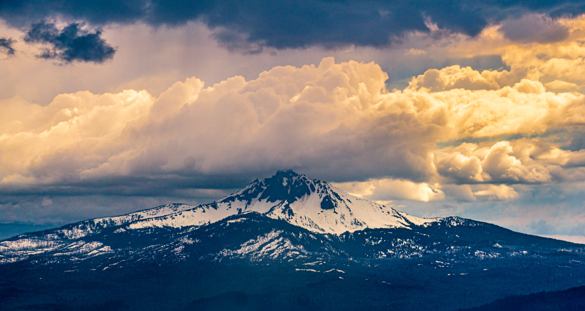
Unpredictable is the best word to describe the weather of high altitude hikes in the Pacific Northwest. One minute the sun is shining on you, then a dark cloud comes barrelling in and covers the sun like a dark lamp shade. Wait a few more minutes, and the wind clears the weather out, removing the hazy atmosphere and revealing towering mountains that were hidden in plain sight. If you want the best viewpoint to watch this type of climate in action, I would suggest hiking up Black Butte near Bend, Oregon.
This extinct volcano offers 360-degree views of several mountains in Central Oregon if you can make it up to the steep hike. While the trail up is only 2 miles, you’ll gain 1,538 feet of elevation (so I hope you like sweating and heavy breathing).
Black Butte Trailhead
Luckily you don’t have to climb the entire butte. The trailhead is located about halfway up. After passing through Sisters, OR, you’ll turn off and begin driving a winding switchback road that starts with smooth pavement and gradually degrades to a bumpy dirt road. It is accessible by any vehicle so long as you don’t care all that much about your suspension. You’ll want to keep the seatbelts fastened on this one.
There are toilets at the trailhead if you need them and a few picnic tables if you need to sit down for a while after your hike and refuel.
Start the Climb
The trail consists of 3 long switchbacks, with steady elevation gain through its entirety. You’ll begin at the Black Butte Trailhead sign and go left up to the trail. While there are no markings along the way, the path is evident and easy to follow. The first third of the hike is shaded by tall Douglas Firs of the Deschutes National Forest.

Mountain Views
At the middle switchback, you’ll leave behind the forest growth and emerge into more mountainous terrain.
The trees will soon thin out, and you’ll be presented with your first views of the Cascade Mountain Range and the valley floor. After about a mile into your hike, you’ll get a first glimpse at the top of Black Butte where a fire lookout sits. The trail from here will become rockier, and you’ll need to be more present and carefully watch your steps. Which becomes increasingly harder to do because the higher up you get, the more beautiful the landscape becomes. Go slow and take in your surroundings. I can tell you that my fat ass needed a lot of “stopping to smell the roses” aka “I can’t breathe and need a rest.” (This was definitely harder than my snowshoe hike up Stargaze Trail which also had me on the struggle bus.)

Look to your right as you ascend the trail, you’ll see Mount Jefferson which is the second tallest mountain in Oregon. Lewis and Clarke named this mountain after President Thomas Jefferson who funded their westward expedition, but the original name given by the Native Americans is Seekseekqua. Mount Jefferson is so remote that it can only be reached on foot or by horse.

If you look behind you, you will see another volcano called Three Fingered Jack. It’s naming origins still remain a mystery. Some say it was named after the Californian Gold Rush Outlaw Joaquin Murrieta whose nicknames included The Robin Hood of the West and Three Fingered Jack. Although this theory is a long shot as no documentation shows Joaquin ever visited Oregon. It’s most likely just named after a random trapper who had three fingers.
Black Butte Firetower
The final switchback will take you to the base of the fire tower. While Black Butte has been used as a fire spotting area since 1910, an actual tower was not built until 1979. The one you’re looking at is not that structure. The original tower was burned down. Ironic right? Well, it was actually purposely set ablaze by the Forest Service to make room for a taller and safer tower. The Forest Service prohibits hikers for going up the tower, but the view is just as good from the base.
To return to the trailhead just retrace your steps.

Trail Tips
- A Northwest Forest Pass is required to park at the trailhead. It costs $5 and you can get it at the trailhead.
- Pay attention to the weather forecast, systems move quicker at elevation.
- Always bring a raincoat when hiking in Oregon
- Don’t make my mistake and try to hike this after already hiking the 6 mile Metolius River Trail the same day.
- Bring Snacks to keep your energy level up


One response
[…] long). Winding through the Deschutes National Forest, the river starts as a spring hidden under Black Butte and ends in Lake Billy […]